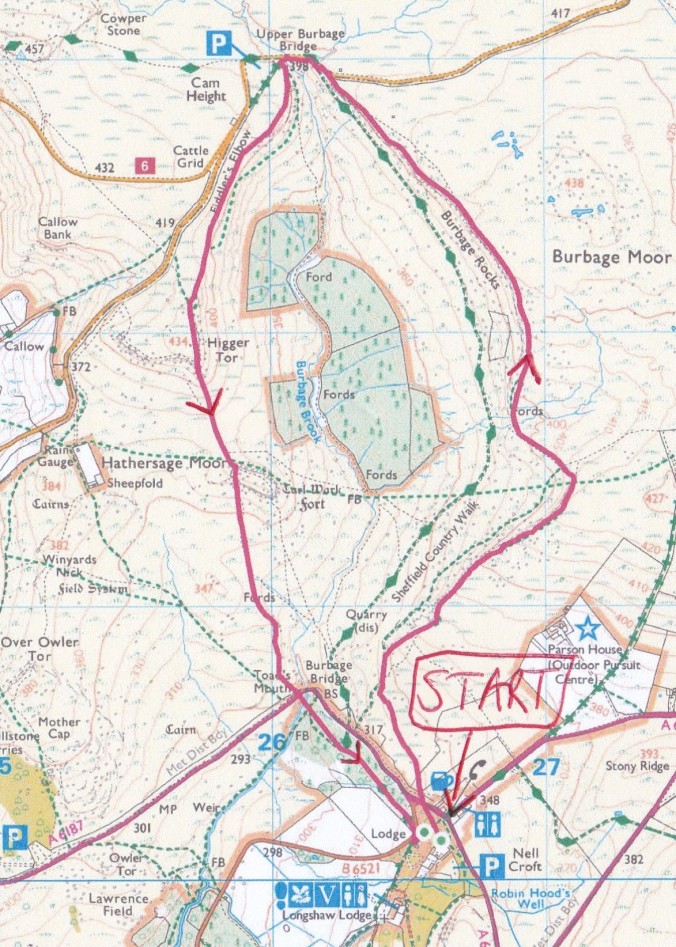
You’ve got a few choices if you’re heading north through a popular part of the Peak District between Longshaw Lodge and Upper Burbage Bridge including a well surfaced path and a slightly more challenging one that follows the steep-sided brook through the valley below. But by far the best has to be the high level route along the edge of Burbage Rocks with breathtaking views west across the national park.
Head to the Fox House pub on the path from the car park that runs parallel to Owler Bar Road. Carry on towards Hathersage for another 100 yards then take the path on the right but pause for a moment at the gate. Carl Wark is straight ahead with Higger Tor behind. Pan left across the moor to another couple of rocky outcrops, Over Owler Tor then Mother Cap. Further left across the valley is the mast on Eyam Edge.
Keep forking right for the high ground. The Great Ridge comes into view as you climb with Win Hill to the right as a bonus. Plus Kinder Scout beyond. And the cement works in the valley. You can’t have everything. Swing left for a cairn and go straight ahead at the crossroads of paths for Burbage Rocks. The rocky bits before were pretty good as well but all the while you can look down at the poor unfortunates on the over congested Sheffield Country Walk and pick out the pillocks struggling along the boggy brookside path. Losers.

Path to Higger Tor.
Take in the information board at Upper Burbage Bridge (there’s a bench lurking behind if you’re interested) then avoid the road by sticking to the path below the two bridges and swing left for Higger Tor. Fork right for the high ground. It’s a bit busier than the first half of the walk but I can just about cope with some company so long as they don’t try to engage in conversation.

Higger Tor (right) with Carl Wark below (centre).
Aim straight over the end of Higger Tor for Carl Wark, have a shufty round the old hillfort then find a gap in the wall to continue your southern trajectory and pick up the path that aims to the right of Lower Burbage Bridge. You’ll see it clearly enough when you’re walking and in the picture below. Fork right just before the brook to go up and over a low piece of higher ground and you’ll spill out on the right hand side of the bridge.
Head straight over the busy road for a path tucked away opposite. Trust me, it’s there behind the vegetation. Drop down to the footbridge, turn left then fork right. After nearly half a mile go straight over the Grindleford road and take a sharp left then a right fork for the car park.

The path to Lower Burbage Bridge.
Start: Longshaw Estate’s Woodcroft car park. It’s free for National Trust members. Plenty of other parking on nearby roads.
Highlight: It would be like choosing your favourite child. This is a seriously good walk with a lot of high spots. Higger Tor it is then.
Lunch: Pack-up at that bench or on a rocky outcrop of your choosing. Or try the steak pie at The Grouse.
Song: Fifty years since the release of Funkadelic’s sixth album, Standing On The Verge Of Getting It On, here’s I’ll Stay.
Distance/map: 5.5 miles. OS Explorer OL1 The Peak District/Dark Peak Area and OS Explorer OL24 The Peak District/White Peak Area. Or use the one below.
OS © Crown copyright [2024] CS-29042-R6R3Z6
